Wildlife Mortality Registry: An Underestimated Data Source for Species and Traffic Protection
A nationwide registry is documenting wild animals that fall victim to road traffic in Germany. Now, the data is also available internationally—providing valuable insights for research and conservation measures.
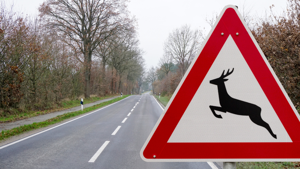
It all began with a practical problem: On certain rural roads, wildlife-vehicle collisions kept recurring, yet there was a lack of reliable data. Were these incidents random, or part of a larger pattern? And how could the risks be reduced—for both humans and animals?
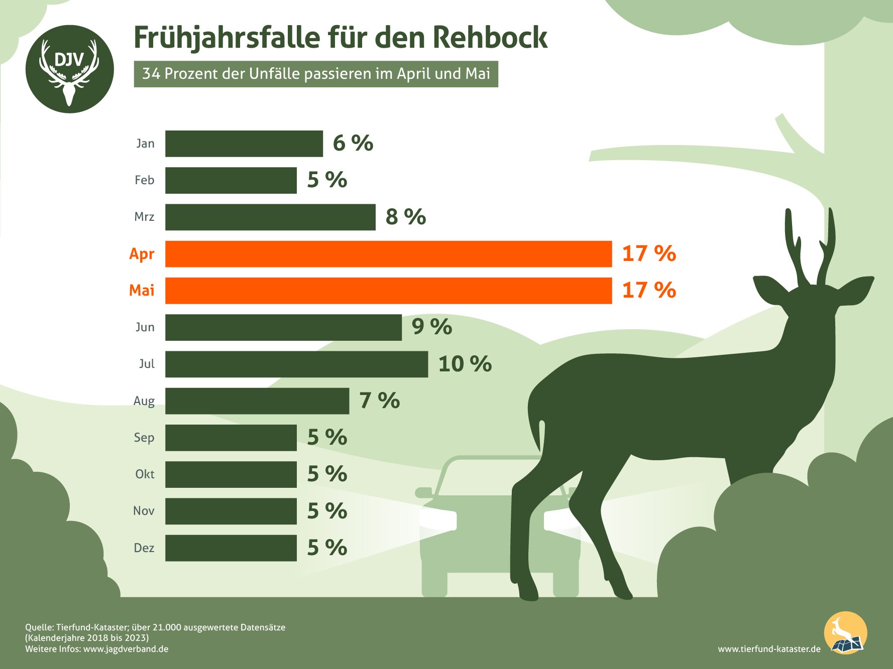
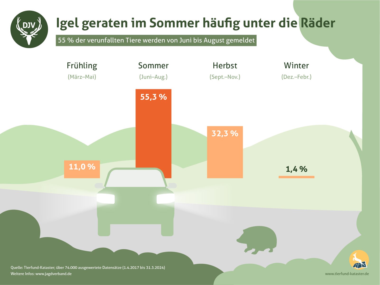
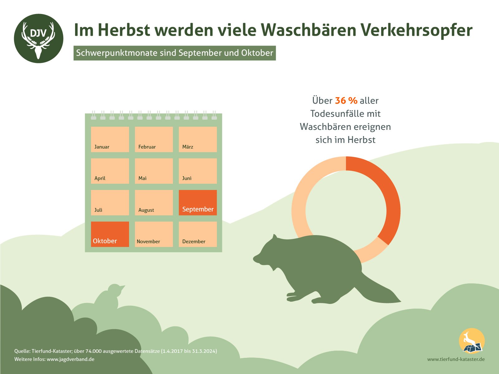
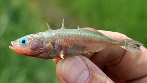
In Schleswig-Holstein, the German Hunting Association (Deutscher Jagdverband, DJV) teamed up with Kiel University back in 2011 to begin systematically recording animal mortalities. This laid the foundation for the nationwide Wildlife Mortality Registry, maintained by the DJV—now one of the most extensive citizen science projects for documenting wildlife losses in Germany. More than 110,000 mortality reports have since been logged, covering deer, wild boar, hedgehogs, foxes, raccoons and more—precisely geolocated and, in most cases, accurately identified to the species level.
A Vital Data Source for Better Wildlife Protection
Now, data on selected species is available for the first time via the international biodiversity platform GBIF (view the registry dataset here) as well as the Living Atlas of Nature Germany (LAND; access the dataset here). This advancement was made possible by close collaboration between the German Hunting Association (DJV), the State Hunting Association of Schleswig-Holstein, and the Living Atlas team within NFDI4Biodiversity. Contributing partners included researchers from the German Centre for Integrative Biodiversity Research (iDiv) Halle-Jena-Leipzig, Friedrich Schiller University Jena, and the Botanic Garden and Botanical Museum Berlin—all part of the NFDI4Biodiversity network. Additional support came from Kiel University, which has provided scientific oversight and coordinated data management.
The new accessibility has far-reaching implications: researchers, public authorities, and environmental planners can now easily incorporate the data into existing analyses and applications. The registry not only shows where certain species are most frequently affected by collisions, it also reveals seasonal patterns, identifies landscape barriers—such as roads, fencing, or wind turbines—and highlights regions in particular need of action.
“The data not only provide valuable insights for scientific research, but also create a foundation for targeted conservation measures—such as efforts to prevent wildlife-vehicle collisions.”
Franziska Baudach, Wildlife Ecology and Monitoring Specialist, German Hunting Association
“As part of GBIF, we've taken an important step in making information about wildlife presence and threats more widely accessible,” says Franziska Baudach, Wildlife Ecology and Monitoring Specialist at the DJV. “The data not only provide valuable insights for scientific research, but also create a foundation for targeted conservation measures—such as efforts to prevent wildlife-vehicle collisions.”
NFDI4Biodiversity Supports with Data Harmonization
Animal mortality reports are submitted via app or web form—usually by hunters or nature-minded citizens. Entries are recorded in a standardized, georeferenced format and collected in a central database. Over the years, this has created a unique nationwide dataset on animal fatalities related to traffic and other causes in Germany.
That these records can now be integrated into broader research infrastructures through standardized interfaces is the result of intense collaboration: NFDI4Biodiversity not only supported the technical implementation but also developed standards to harmonize these heterogeneous datasets and ensure their long-term usability. As such, the project serves as both a scientific and methodological model—showcasing how citizen science, environmental monitoring, and research data infrastructures can interoperate to produce meaningful insights from locally gathered observations.
Applications Beyond Academia
The data offer a wide range of potential uses: in urban and transportation planning, for example, they help identify early conflicts with wildlife habitats—such as during the design of wildlife crossings or fencing, in the prevention of wildlife-vehicle collisions, in early detection of animal diseases like African Swine Fever, or for monitoring invasive species.
For instance, reports of wild boar fatalities from the registry are automatically forwarded to the Friedrich Loeffler Institute via an integrated interface.
The data are also increasingly relevant to biodiversity research—supporting the modeling of species distributions, assessment of human impacts, and identification of ecological corridors between habitats. Of particular value is the integration with other environmental and geospatial datasets made possible through connections with GBIF and the Living Atlas: only in combination with information on land use, habitat types, climate conditions, or protected areas can researchers identify patterns, assess risks, and draw informed conclusions for both science and conservation.
The “Datens(ch)atz Tierfund-Kataster” is also featured in a blog post on the Living Atlas of Nature Germany (LAND): Read the article here.

News

New interface connects official species observatio...

Season's Greetings 2025
Recap: Joint Plenary of NFDI4Biodiversity & NFDI4E...
NFDI4Biodiversity enters second phase in October: ...

Wildlife Mortality Registry: An Underestimated Dat...

How Archival Data Can Inspire New Research
Open, but legally sound: What a new legal review r...

Streamlined Support: Ten NFDI Helpdesks Strengthen...
DFG Funding Recommendation and Coalition Agreement...